Projects
I work across a wide array of natural-resource and creative projects—from spatial modeling and indices development to citizen-science platforms and agent-based simulations. Click each header below to learn more.
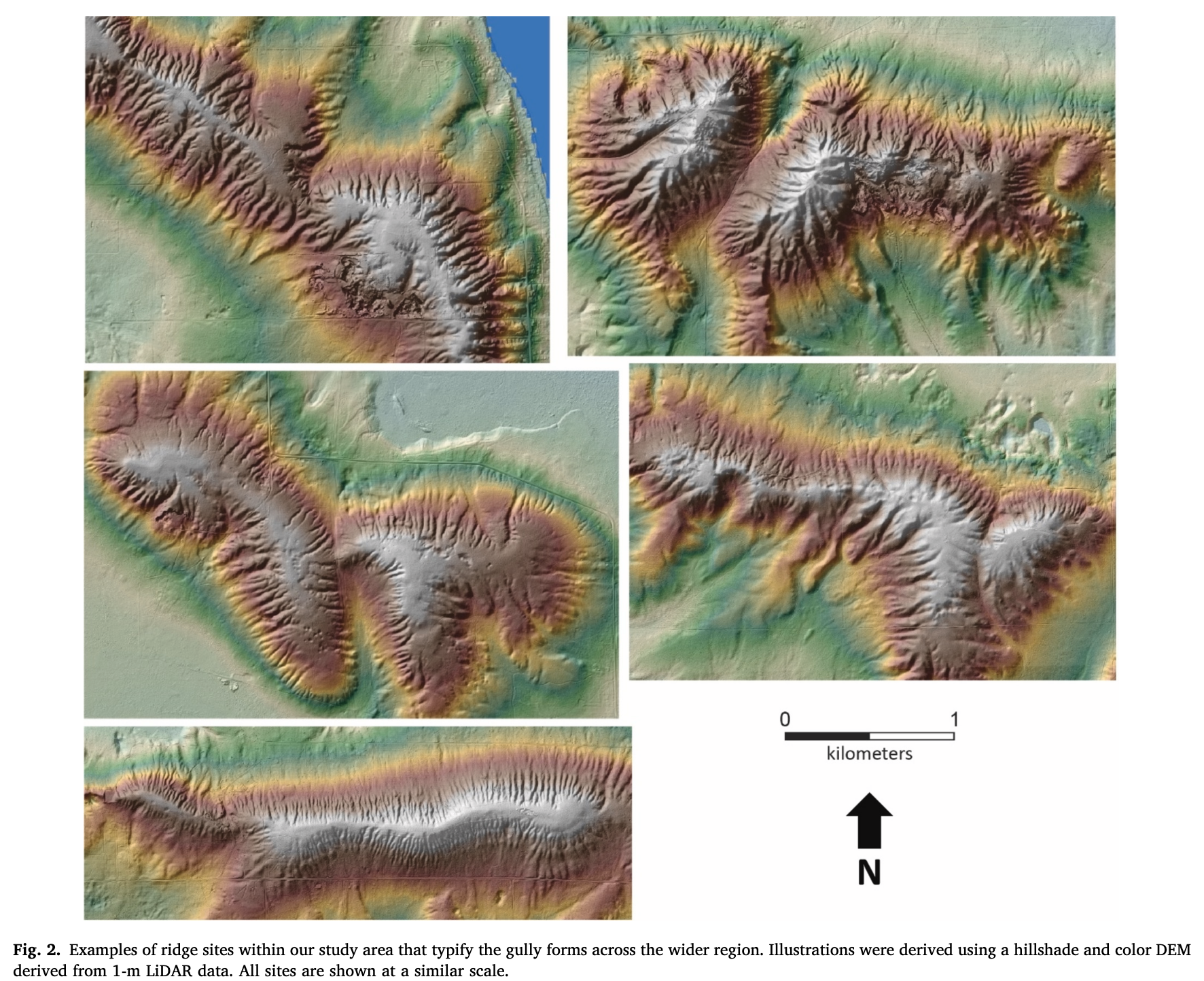
Northern Hardwoods Resilience Project
This project examines how the U.S. Forest Service and state partners use BMP guides and management objectives to design and evaluate silvicultural treatments in hardwood systems, including oak–hickory stand goals. It traces how timber management plans align ecological targets with public-interest outcomes such as sustained yield, habitat quality, and local economic benefits. It compares guidance documents to prescriptions and post-treatment assessments, and it also tracks how private landowner objectives intersect with public guidance through cost-share programs and technical assistance.
Agroforestry in Lake States
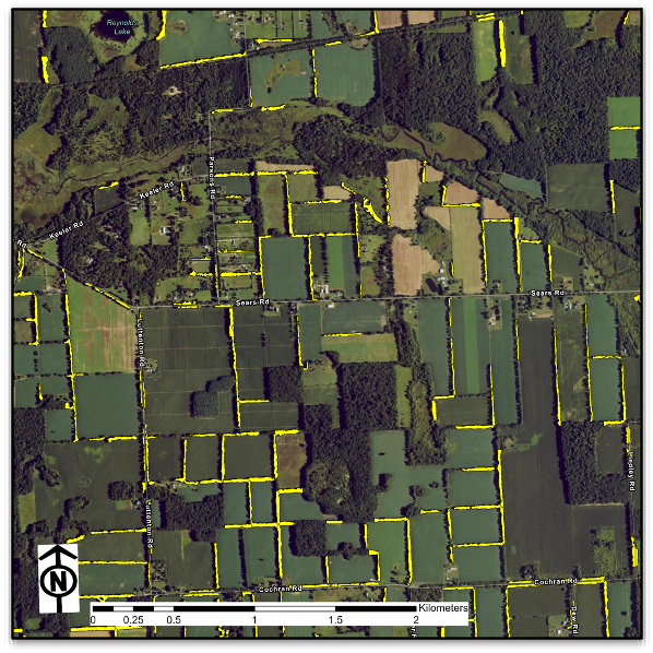
This project culminated in my master’s thesis on the spatial elements and human dimensions behind agroforestry adoption in the lake states, available here: https://doi.org/doi:10.25335/9cez-1t55. It uses agroforestry as a lens on how practice standards, technical assistance networks, and partner guidance move across land tenures and into on-the-ground decisions. That work is continuing, with ongoing emphasis on how adoption pathways and feedback loops update guidance over time.
Synthesis of Citizen Science on Public Lands

This project treats public lands as engines of citizen science, using a meta-analysis of iNaturalist to map where observations occur and to quantify disparities between public units and private lands. It identifies management and personal decision-making levers that shape observation density, taxonomic breadth, and verification outcomes. It evaluates practices such as geoprivacy protocols, targeted bioblitzes, interpretive signage, and co-stewardship partnerships as pathways to strengthen data quality and integrate observations into planning and adaptive management.
Land Cover in Michigan

This project produces a statewide 0.6 m land-cover and canopy map for Michigan from 2022 NAIP imagery using a U-Net workflow. It is designed for practical planning, monitoring, and policy evaluation related to precision conservation, with open datasets and reproducible code intended for public and agency use.
Roads and their Genesis/Utilization on USFS lands
This project examines how timber roads come into being, the standards that guide their design and maintenance, and the transitions they undergo after harvests conclude. It follows roads through a life cycle that includes planning, construction, operational use, and post-harvest decisions such as decommissioning or repurposing. It links engineering guidance and environmental compliance to social expectations about access, jobs, and resource supply, with attention to who benefits, who bears maintenance burdens, and how decisions constrain future options.
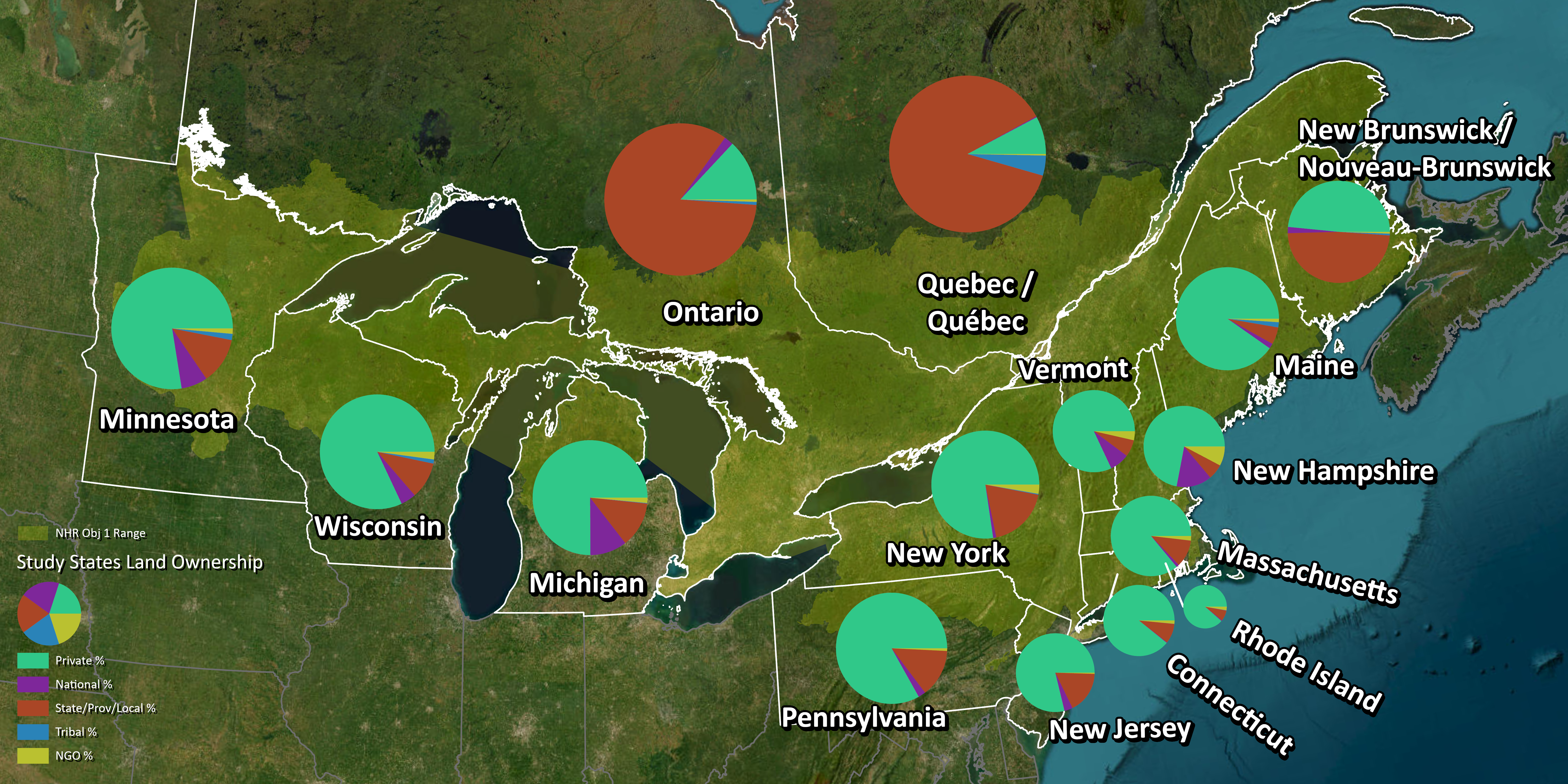
Woody riparian buffer index and functional forest class
This project operationalizes a Woody Riparian Buffer Index with bank-aware, distance-decay scoring in both vector and raster forms to quantify riparian protection along streams and lakes. It generates watershed summaries and gap maps to support restoration targeting, and it tests how sub-meter inputs improve detection of narrow buffers and edge fidelity relative to coarser products.
iNaturalist administration + guidance
In my time working for the National Park Service, I built and implemented iNaturalist projects at a nationwide scale to increase user engagement, supporting how parks organize observations into usable, consistent data streams across units. That work continues through ongoing volunteer contributions focused on maintaining and improving projects, strengthening data quality, and helping parks translate observations into stewardship and interpretation value. The emphasis is practical implementation: clear project structure, sensible geoprivacy and sensitive-species handling, and repeatable approaches that support bioblitzes, verification, and public engagement. More details for this work are avilable here: https://www.inaturalist.org/projects/national-park-service
Responsible stewardship and access
My work in general frames stewardship as a public-interest practice where standards, professional judgment, and transparent guidance help earn trust across constituencies. It focuses on how access, safety, maintenance capacity, and ecological obligations interact in real decisions, including tradeoffs about who benefits from access and who bears long-run costs. The emphasis is a civic ethos of stewardship in service of the public, matched to achievable outcomes and evidence.
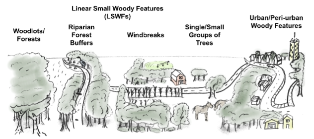
Relict Gullies and Thermo-erosion in Northern Lower Michigan
- This semester-long graduate seminar mapped and characterized thousands of shallow, relict gullies incised into sandy upland ridges in northern Lower Michigan, using high-resolution terrain data to delineate gully networks and contributing basins. The project tested whether these dense, downslope-aligned channels could form in highly permeable sands without frozen ground, concluding that ice-rich permafrost likely promoted runoff and thermo-erosion during the Late Pleistocene. The resulting paper links gully morphometry and spatial patterns to past periglacial hydrology, and it provides a scalable workflow for studying relict gully networks in other cold-region landscapes: Read the paper.
Mountain Pine Beetle Agent Based Model
.gif)
- Final project of GEO 869 ABM: An agent-based modeling project done as a final project for GEO 869 at MSU that simulates mountain pine beetle dynamics and explores how different assumptions on life cycle and tree mortality can change spread and outcomes. Built as a course-driven model, it serves as a sandbox for linking ecological disturbance processes to decision rules and management scenarios.
Upcoming Projects
- More to come!